For many Stafford families, North Anna–Bristers is not an abstract line on a regional grid map. The potential corridors run through a county where subdivisions, school campuses, parks, woods and long-held private property sit close together. If an overhead route is ultimately approved, some residents could look out from their homes at a cleared utility corridor and galvanized-steel structures that Dominion’s own illustration says would average about 170 feet for monopoles and 270 feet for H-frame structures.
No Stafford route has been approved. Dominion says the northern Thornburg–Bristers section is still under route, technical and environmental review, with a separate SCC application planned for 2027.
A new industrial corridor through lived-in places
The northern project would carry both 500-kilovolt and 230-kilovolt transmission facilities from a proposed Thornburg substation in Caroline County, through Stafford, to the existing Bristers substation in Fauquier County. Dominion describes the connected projects as a way to strengthen grid reliability and move power where demand is growing. But the same infrastructure can create a lasting burden where a new route crosses developed land.
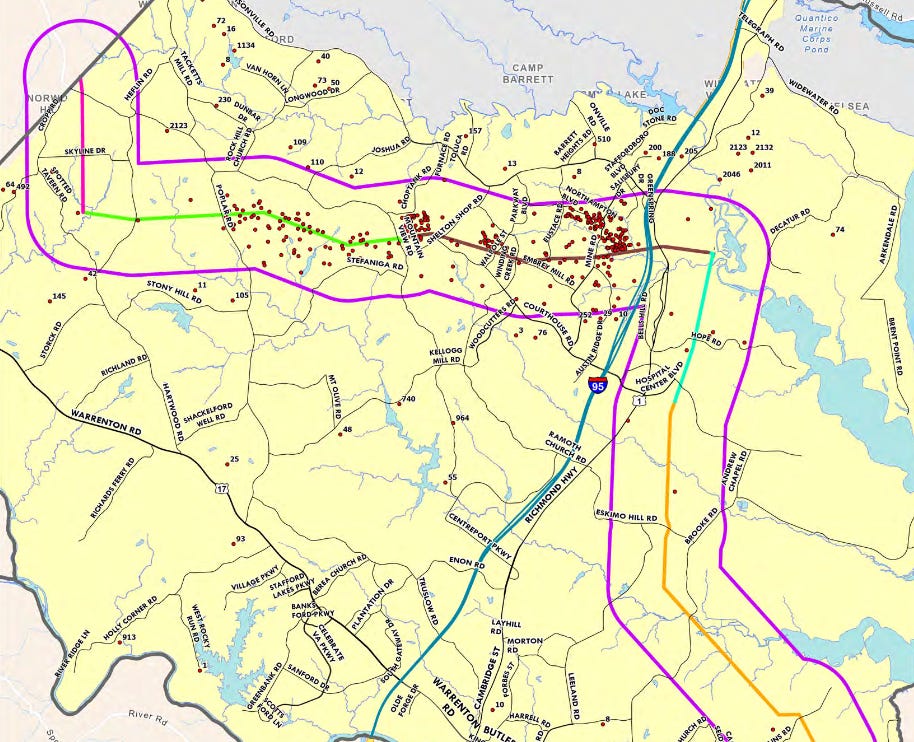
Route concepts discussed during outreach have brought the proposal close to—or across—residential property, school land and community open space. A transmission easement can limit how the affected strip is used, require long-term vegetation management and give utility crews access for inspection, maintenance and emergencies. For a homeowner, that can mean losing trees and privacy, living beside a permanent cleared corridor, and facing uncertainty about resale value and future use of the property. Those consequences vary by final route and easement terms, which do not yet exist for an approved Stafford alignment.

Backyards, neighborhoods and direct property impacts
Stafford County’s own public survey provides the clearest evidence of how sharply residents view the proposal. According to the county staff report summarized by FXBG Advance, 465 people responded: 93% were very or somewhat unfavorable, 3% were favorable, and 5% were unsure or had no opinion. The survey was not a scientific countywide poll, but it is an important record of the residents who chose to participate.
The county summary identified recurring concerns about property values, health and safety, environmental and wildlife impacts, children and other vulnerable populations, quality of life, and a lack of trust or clear information. Residents near the route area identified as segment 5 were especially likely to report direct property impacts and concerns about schools. Seventeen percent of respondents said Dominion already held an easement on their property; another 30% were unsure.
Citizen coalition Towering Concerns says its own geospatial work found thousands of Stafford homes within 1,000 feet of one or more route concepts and hundreds of properties directly affected. Those are advocacy-group estimates, not an SCC finding or a final parcel count, and Save Stafford has not independently reproduced the analysis. They nevertheless explain why the words “potential route” feel immediate to neighborhoods: even an alternative that is never selected can pass behind a house, across a wooded lot or beside a school on the maps residents are being asked to study.
Schools and community spaces are part of the fight
Local reporting says route concepts in the heavily engaged segment 5 area were near Embrey Mill and Augustine and a group of public schools that included Hampton Oaks, Winding Creek and Margaret Brent elementary schools; Rodney Thompson and H.H. Poole middle schools; and Mountain View High School. School Board members questioned Dominion about proximity to campuses, structure heights and whether sections could be placed underground during a December 2025 work session.
It is important to be precise: a line near a school on a study map is not an approved line, and claims that particular fields or facilities must be demolished cannot be treated as final until an application identifies proposed and alternative routes in detail. But proximity alone is a legitimate siting issue. School campuses are difficult to relocate, serve children every day and often double as parks, athletic fields and gathering places for whole neighborhoods.
The physical scale is difficult to minimize
Dominion’s May 2026 “Typical Proposed Structures” sheet depicts galvanized-steel monopoles averaging 170 feet and H-frame structures averaging 270 feet. The utility cautions that the visualization is for discussion, is not to scale and may change after public, engineering and regulatory review. Even with that caveat, these are not ordinary roadside distribution poles. They are regional transmission structures intended to carry very high-voltage circuits across long distances.
Advocacy groups describe a roughly 120-foot cleared corridor for portions of the proposal. That width should be treated as a planning claim until Dominion’s future SCC application supplies route-specific right-of-way dimensions. Whatever the final number, overhead transmission rights of way generally must remain accessible and clear of vegetation that can threaten the conductors. That is why residents focus not only on the poles but on the permanent opening cut through woods and between homes.

Why Dominion says the line is needed
Dominion says the North Anna–Bristers connection would strengthen reliability, improve resilience and energy security, and help the grid carry electricity from a diverse set of generating sources. The line is also part of a much larger regional transmission buildout. Potomac Local reported that the separate proposed ValleyLink 765 kV backbone would feed into the same 500 kV network, including the north end of the Bristers corridor.
That regional explanation is one reason some Stafford residents are angry: they see a large local land-use burden attached to electricity growth that extends beyond their county. The exact beneficiaries, cost allocation and demonstrated need will be central questions in the SCC process. They should be tested against the formal engineering record rather than reduced either to Dominion’s benefits language or opponents’ assumptions.
Would burying the line solve the conflict?
Survey respondents showed substantially more support for underground construction, and Stafford planning discussions have included underground placement as a county preference in sensitive locations. Underground transmission can reduce the permanent visual presence of towers, but it is not impact-free: construction requires excavation, wider temporary work areas, specialized transition stations, and substantially different costs and maintenance practices. Whether underground alternatives are technically feasible and reasonably priced for any part of this 500/230 kV project is a matter for detailed evidence in the SCC case.
The project was split—and Stafford gained time
The original proposal was described as one approximately 70-mile project from North Anna in Louisa County to Bristers in Fauquier County. Dominion now plans two applications. The southern North Anna–Thornburg section is scheduled for filing in fall 2026. The longer northern Thornburg–Bristers section—the one crossing Stafford—is being held for a separate filing planned in 2027 while Dominion continues reviewing possible routes, technical needs and environmental factors.
That delay is not a cancellation. It is, however, meaningful. Until the northern application is filed, there is no final proposed route for the SCC to approve, reject or modify. The extra time gives property owners, schools, neighborhoods and county officials an opportunity to document impacts, compare corridors, demand clearer answers and build a record that can later be placed before the regulator.
Who makes the final decision
Virginia’s State Corporation Commission must certify transmission lines at or above 138 kV. The SCC will evaluate whether the project is needed and decide the authorized route and structures. State law also requires consideration of whether impacts on scenic areas, historic districts and the environment have been reasonably minimized. Stafford County can adopt Comprehensive Plan guidance and advocate for residents, but it cannot by itself approve or veto the line.
Use Dominion’s GeoVoice map to check route concepts against an address; save screenshots and parcel records; document wells, septic systems, trees, conservation features and historic resources; submit comments to Dominion; follow Stafford County meetings; and prepare to participate in the SCC case after the 2027 filing. Comments sent now do not replace formal SCC testimony later.
Save Stafford’s position: A regional reliability project should not treat established Stafford neighborhoods, school grounds and private backyards as the path of least resistance. Dominion and state regulators should be required to demonstrate need transparently, compare less damaging corridors, examine underground and existing-right-of-way alternatives, and minimize direct harm before any route is approved.
Sources, documents & image credits
Read the original record
Dominion Energy — current North Anna to Bristers project pageAugust 2026 · Open original source ↗Dominion Energy — typical proposed structuresMay 2026 · Open original source ↗FXBG Advance — Stafford survey finds 93% unfavorableMay 4, 2026 · Open original source ↗Fredericksburg Free Press — Stafford planners recommend transmission guidelinesJune 11, 2026 · Open original source ↗Towering Concerns — citizen coalition project informationReviewed August 2026 · Open original source ↗Shelton’s Run Community Association — neighborhood concerns and advocacy estimateApril 1, 2026 · Open original source ↗Potomac Local — relationship to the separate ValleyLink proposalFebruary 13, 2026 · Open original source ↗Support Save Stafford
Independent local information. No paywalls. No advertising.Research like this takes time and sometimes requires obtaining public records. Community support helps Save Stafford continue making this information freely available.
No subscription required. Contribute only if you choose. Financial contributions do not purchase editorial influence.